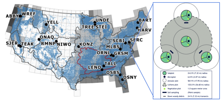
Understanding and managing forests is crucial to understanding and potentially mitigating the effects of climate change, invasive species, and shifting land use on natural systems and human society. However, collecting data on individual trees in the field is expensive and time consuming, which limits the scales at which this crucial data is collected. Combining large scale survey efforts with remotely sensed imagery from satellites, airplanes, and drones provide the potential to observe ecosystems at much larger scales than using field data alone.
Dr. Sergio Marconi (He/Him)
Post-Doc at University of Florida
My research focuses on AI for forest cross-scale ecology and conservation
Related
Publications
A benchmark dataset for canopy crown detection and delineation in co-registered airborne RGB, LiDAR and hyperspectral imagery from the National Ecological Observation Network
Forests provide essential biodiversity, ecosystem and economic services. Information on individual trees is important for understanding the state of forest ecosystems but obtaining individual-level data at broad scales is challenging due to the costs …
Expanding NEON biodiversity surveys with new instrumentation and machine learning approaches
A core goal of the National Ecological Observatory Network (NEON) is to measure changes in biodiversity across the 30‐yr horizon of the network. In contrast to NEON’s extensive use of automated instruments to collect environmental data, NEON’s …
RandCrowns: A Quantitative Metric for Imprecisely Labeled Tree Crown Delineation
Supervised methods for object delineation in remote sensing require labeled ground-truth data. Gathering sufficient high quality ground-truth data is difficult, especially when targets are of irregular shape or difficult to distinguish from …
A remote sensing derived data set of 100 million individual tree crowns for the National Ecological Observatory Network
Forests provide biodiversity, ecosystem, and economic services. Information on individual trees is important for understanding forest ecosystems but obtaining individual-level data at broad scales is challenging due to the costs and logistics of data …
Harnessing the NEON data revolution to advance open environmental science with a diverse and data‐capable community
It is a critical time to reflect on the National Ecological Observatory Network (NEON) science to date as well as envision what research can be done right now with NEON (and other) data and what training is needed to enable a diverse user community. …
Rethinking the fundamental unit of ecological remote sensing: Estimating individual level plant traits at scale
Functional ecology has increasingly focused on describing ecological communities based on their traits (measurable features of individuals that affect their fitness and performance). Analyzing trait distributions within and among forests could …
DeepForest: A Python package for RGB deep learning tree crown delineation
Remote sensing of forested landscapes can transform the speed, scale and cost of forest research. The delineation of individual trees in remote sensing images is an essential task in forest analysis. Here we introduce a new Python package, DeepForest …
Cross-site learning in deep learning RGB tree crown detection
Tree crown detection is a fundamental task in remote sensing for forestry and ecosystem ecology. While many individual tree segmentation algorithms have been proposed, the development and testing of these algorithms is typically site specific, with …
Rethinking global carbon storage potential of trees. A comment on Bastin et al.(2019)
Bastin et al. 2019 use two flawed assumptions: 1) that the area suitable for restoration does not contain any carbon currently, and 2) that soil organic carbon (SOC) from increased canopy cover will accumulate quickly enough to mitigate anthropogenic …
Individual tree-crown detection in RGB imagery using semi-supervised deep learning neural networks
Remote sensing can transform the speed, scale, and cost of biodiversity and forestry surveys. Data acquisition currently outpaces the ability to identify individual organisms in high resolution imagery. We outline an approach for identifying …
Continental-scale Hyperspectral tree species classification in the National Ecological Observatory Network
Advances in remote sensing imagery and computer vision applications unlock the potential for developing algorithms to classify individual trees from remote sensing at unprecedented scales. However, most approaches to date focus on site-specific …


